
By MICHAEL MCCARTHY, Vancouver Sun
Published on: November 28, 2016 | Last Updated: November 28, 2016 10:45 AM PST
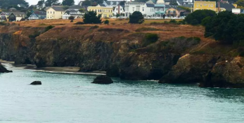
California teems with over 38 million people and it seems every square inch of land is packed. Not so. The Lost Coast is virtually empty and there are good reasons for that. Just finding the Lost Coast can be a puzzle. If you look on your map, it’s the area of land jutting out into the Pacific near the northern end of the state, the most westerly piece of land in America.
Until recently, the only way to approach the phenomenally beautiful coast was from the town of Eureka near Oregon, driving south to the hamlet of Petrolia and then trekking way out to the coast. Why is it “lost?” First off, there’s the fog. This section of extremely rugged coast is frequently lost in mist. Many ships have sunk here. There are no roads, towns or villages and even campsites are rare. Officially the Coast is known as the King Range National Conservation Region. Intertidal-zone hiking, sneaker waves, wind exposure, poison oak, creek crossings (no bridges, some impassible after storms), rattlesnakes and black bears deter a lot of hikers.

However, the folks at the Mendocino County tourism office told me a secret. There is now a new road leading into the Lost Coast from the south. You can drive the entire way to the trailhead if you have exact directions.