by Eric Brightwell – KCET.org
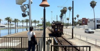
Any decent map of rail lines in Los Angeles has to include the rails used by Amtrak, Metro, and Metrolink. Extra credit if they also include the tracks used by BNSF Railway and Union Pacific Railroad. Including novelty rails like Angels Flight, Travel Town Railroad, or the trolley lines at The Americana at Brand and The Grove is probably going too far. Then there’s the Waterfront Red Car Line in San Pedro, which in my mind, lies somewhere in between novelty rail and public transit. Though now in operation for more than a decade, I was only just made aware of it when I saw it included on a map alongside Metro and Metrolink and decided to check it out.
Anyone who’s at all interested in mass transit has probably heard of the Pacific Electric rail system — popularly known as the Red Cars or Big Red Cars. Covering over 1,000 miles, it was once the largest electric interurban rail system on the planet. The last journey undertaken by the last train on the last line was the 20-mile trek from Los Angeles to Long Beach in 1961, along a right-of-way that was revived by the Metro Blue Line in 1990.


